The Last Standing Mound In Mound St. Louis City Is For Sale
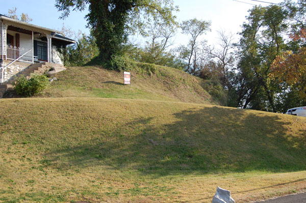 |
| Sugarloaf Mound, photo by Andrew B.Weil |
November 7, 2008
It has recently come to the attention of Landmarks Association that the land containing the last standing Native American mound in St. Louis City is currently for sale. Sugarloaf Mound had been standing watch on the Mississippi for hundreds of years when Marquette and Joliet slipped by on their way south in 1673. Pierre Laclede passed the bluff-top landmark while searching for a site for his trading post, as did August Chouteau and his gang of workers on their way to begin construction of our city. The mound survived the New Madrid earthquake, and bore witness when the river ran backwards. Ulysses Grant would have traveled past Sugarloaf while hauling firewood north on Broadway for sale in St. Louis. Sugarloaf stood when the riverfront burned, and cholera raged, when the railroad arrived, and when the Mississippi was finally spanned. The mound has witnessed our past; it is our responsibility to ensure that it witnesses our future.
The impending sale of the property presents an opportunity to re-examine the place that mounds hold in the history (and prehistory) of our city. It also affords a chance to consider our responsibilities toward these ancient structures, a matter that has been publicly discussed in the city since at least the 1830's. Unfortunately, the voices calling for St. Louisans to be stewards of their mounds have always been lost in the clattering din of picks and shovels. While once prevalent enough in St. Louis to earn us the nickname "Mound City," today Sugarloaf is the sole surviving example of St. Louis' prehistoric built-environment.
The elderly owners (understandably) do not have the money to simply donate the land to a custodial organization; it is reluctantly being sold to help finance long-term care. Unfortunately, it is not beyond the realm of possibility that a new owner might value the property solely for its excellent river view, or its industrial zoning and proximity to the highway. History provides a strong indication that many people simply don't comprehend the irreplaceable historical and cultural significance of a site of this kind. While the mound itself was listed in the National Register of Historic Places in 1984 (and is subject to preservation review by the city of St. Louis Cultural Resources Office), protection from demolition or alteration is not guaranteed. Currently, concerned citizens and various organizations are exploring the possibility of purchasing the land and making it into a public park. Fortunately, important political figures such as Representative Russ Carnahan and 9th Ward Alderman Ken Ortmann have expressed their interest in seeing the mound preserved. It is hoped that a solution can be found that will ensure access to the site for future generations while acknowledging its place in St. Louis' history and its cultural importance to Native Americans. More information about this effort will follow and provisions for donations will be detailed if fundraising efforts are implemented.
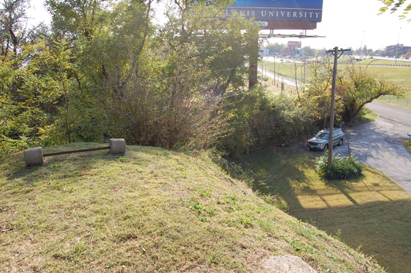 |
| View from mound facing southwest, photo by A.B. Weil |
The prehistoric mounds that once stood in St. Louis are presumed to have been associated with Middle - and Late Woodland (approximately 400 BC -900 AD) and Mississippian (approximately AD 900-1500) peoples, though their obliteration has somewhat inconvenienced the pursuit of definitive cultural associations. The largest complex of mounds in the city was a major Mississippian civic-ceremonial center located just north of Laclede's Landing. The cultural/temporal association of this group is known from analogous extant sites as well as detailed historical descriptions of the mounds themselves, their arrangement, and several associated diagnostic artifacts. The north St. Louis mound complex was presumably tied both politically and culturally to both the East St. Louis mound group, and Cahokia. While the sites had been abandoned by their builders for hundreds of years when European and African people arrived in the vicinity, the mounds were still quite prominent features on the landscape. Eighteenth century French maps indicate that settlers of the area took notice of the unusual earthen structures and used them as landmarks. Additionally, mounds are common features on maps of St. Louis from the first half of the 19th century, and are clearly visible in several representations of the city such as John Caspar Wild's 1840 lithograph of the north riverfront (In the collections of the Missouri Historical Society).
The best known account of the north riverfront mound group was created by Dr. Thomas Say and Titian Peale, naturalists attached to Major Stephen Long's 1819 expedition up the Missouri River. The two men made detailed records of 25 Indian mounds in all and described their systematic orientation around a central plaza. To the south of the plaza was an unusual earthen stair-step feature commonly known as the "Falling Garden" and to the north, a single large mound known imaginatively as "Big Mound." Destruction of these mounds began in the 1830's as the street-grid was extended to the north of downtown. While a majority of St. Louisans (apparently) regarded the mounds as little more than novel impediments, tourists marveled at their majesty. A visitor named Edmund Flagg wrote in 1838;
"It is a circumstance which has often elicited remark from those who, as tourists, have visited St. Louis, that so little interest should be manifested by its citizens for those mysterious and venerable monuments of another race by which on every side it is environed."
He continued and reflected upon the opportunity the city was currently squandering by destroying the mounds rather than preserving them and putting them to public use saying;
"When we consider the complete absence of everything in the character of a public square or promenade in the city, one would suppose that individual taste and municipal authority would not have failed to avail themselves of the moral interest attached to these mounds and the beauty of their site, to have formed in their vicinity one of the most attractive spots in the West. These ancient tumuli could, at no considerable expense, have been enclosed and ornamented....and thus preserved for coming generations (Quoted in Marshall, 1992).
The foresight of this progressive sentiment appears to have been completely lost on the city and its residents and by the early 1840's much of the prehistoric landscape along the north riverfront bluffs had been significantly degraded.
The mounds were landmarks in St. Louis in several senses of the word. They were used by surveyors as fixed points from whence to measure distances, they were used by people moving about the city as a way to orient themselves, and they created an early identity for St. Louis as the Mound City. In addition to replacing the earlier French appellation of pain court (a derogatory reference to early St. Louisan's preference for carousing over farming and the resultant bread shortages), this nickname gave us an identity that was based on our unique topography. We were indeed the Mound City and the mounds gave us a sense of place. This place however would not last. An 1843 newspaper article stated;
"A person absent from the city only a few years might easily lose himself in this section [near the mounds], for of the old landmarks he would find but few remaining. Even the ancient mounds, for which St. Louis has long been noted and which lie in this quarter, seem to have hidden their diminished heads before the advancing wave of civilization. Unprotected by any law and with no thought on the part of the citizens to preserve them from destruction, these....wonders soon fall prey to the encroachments of civilization (Quoted in Marshall, 1992).
The destruction continued into the 1850's when all the mounds in the near north riverfront group, except for a portion of "Big Mound," were gone. In 1854, Adam B. Chambers, editor of the Missouri Republican along with a group of concerned citizens expressed their hope that this last vestige of the formerly grand site would be preserved. In an editorial published in that year Chambers wrote;
"It is with pain that we learn that one of the oldest monuments of the city-that indeed from which it derives the name of ‘Mound City,' is about to be leveled...[Big Mound] is an object that ought not only to be spared, but ought to be preserved. ..If there is any one spot in the city that deserved the protection f its inhabitants more than all others, it appears to us that the Big Mound is that spot (Quoted in Marshall, 1992).
By the end of the Civil War, the mound was barely recognizable from its original form; piecemeal destruction had mutilated its shape, reduced its height, and contributed to unchecked erosion. Brooklyn Street cut through a section of the monument, and sand and clay had been mined from its interior for building material. An 1865 article in the Post Dispatch noted that
"...the "Mounds," which within the memory of the oldest inhabitants, were so numerous on the present site of St. Louis as to obtain for the city the designation of the ‘Mound City," are fast disappearing under the grasping, money making spirit of the age. In a few years these...memorials...will be entirely destroyed to the great regret of future antiquarians" (Quoted in Marshall, 1992).
Big Mound was finally destroyed completely in 1869 and its fill ignominiously sold to the North Missouri Railroad to build track alignments. During removal, thirty-two burials were found within in two chambers, one of which was estimated to be 25 feet below the surface of the mound. In following years, the rest of the mounds in the city were gradually and purposefully destroyed. Mounds that once dotted the landscape all along the north riverfront fell to the grader and the shovel. A mound once situated on the grounds of the Christian Brothers College in north city (now Sherman Park) was destroyed, as was another located at Jefferson and Olive streets. In preparation for the World's Fair, two groups of mounds (totaling 16 in all) were destroyed along the River des Peres in Forest Park. Today, the only mound left in the Mound City is Sugarloaf.
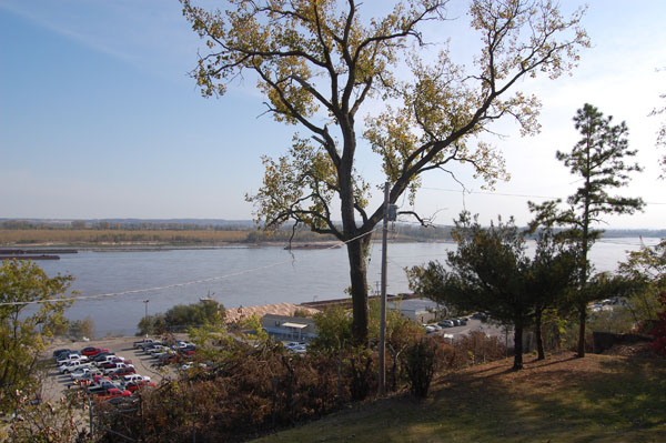 |
| View facing southeast from Sugarloaf, photo by A.B. Weil |
Sugarloaf has escaped the fate of the other St. Louis mounds through a combination of luck and geography. The mound is situated at the very edge of a steep bluff half-way between the historical boundaries of Carondelet and St. Louis. In fact, it was used as a marker for the southwestern corner of the town limits when St. Louis was incorporated in 1809, and served as a landmark that delineated the St. Louis commons from those of Carondelet. The mound's position high above the riverfront and railroad protected it from the heavy industrial development that began to connect St. Louis and Carondelet in 1850's, though it was damaged by operations at an adjacent quarry. Also, the fact that it is far from the historical centers of both Carondelet and St. Louis insulated the land from heavy development pressure until efficient public transit opened the farther reaches of the city to commuters at the turn of the 20th century.
The city block where the mound sits began developing primarily after 1910 and the home on top of Sugarloaf was built in 1928. While popular legend posits that the house, a one-story brick bungaloid (thankfully at least partially built on a slab), was built by a riverboat pilot who required a view of the mighty Mississippi, the truth appears to be somewhat less romantic. The 1929 Gould's Red and Blue Book lists Frederick E. and Nellie Adams at the address, and the 1930 census reveals that Frederick worked as a molder at an Iron foundry. The home has essentially been continuously occupied since its construction, a condition which ironically has contributed to the preservation of the mound. In several articles published in both the Globe Democrat in the 1930's and 40's, historian McCune Gill advocated preservation of the last mound in the city as a public park, but as the land was privately held nothing came of his efforts. The current owners/sellers purchased the property in 1962 following a ten year wait for the home to come on the market. According to listing agent Leigh Maibes, the family has always appreciated the mound's significance and graciously accommodated curious visitors for almost fifty years.
With the departure of the current owners, the citizens of St. Louis have an opportunity to reclaim this monument as part of the shared history of our city and region. Landmarks Association is currently working closely with other concerned organizations and individuals to explore ways to ensure the safety of the monument, and hopefully provide public access and interpretation of the site. While nothing can be done to bring the other mounds of Mound City back, we can have an impact on what happens to Sugarloaf. In this case, as in so many others, looking back on what we have lost should focus our attention on what we might still preserve.
Author's Note: I am indebted to the excellent primary research of Dr. John Marshall for much of the content of this article. Marshall published his work in the Missouri Archaeologist, Volume 53, December, 1992. His article was entitled, The St. Louis Mound Group: Historical Accounts and Pictorial Depictions.